Road Closures and Parking Suspensions during Notting Hill Carnival

Information and maps on traffic measures for Notting Hill Carnival.

Notting Hill Carnival 

Each year, a number of road closures and parking suspensions are required to facilitate Carnival – from the floats to sound systems to traders – and for crowd management, to ensure a safe and successful event.

Across much of the Carnival footprint, non-authorised vehicles will have no access during carnival, and some measures are put in place beforehand to set up the event, with closure points managed by the Metropolitan Police

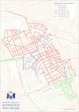
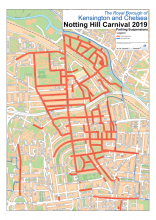
The following maps show traffic measures:

  • to use the interactive map, enter your postcode or road into the search bar and use the zoom in option to view the coloured line for your road, and click on the line to view the measure

All of these maps make reference to schedules, which relate to each of the following traffic management measures and their timings. Please do consider the closure measures on the roads around yours, and whether your road has more than one measure, as these will impact your journey.

Schedule 1

Full closure (red on map)

  • Vehicles cannot use these roads throughout the 48-hour closure
  • This includes restrictions for waiting, parking or unloading.
  • Cars already parked in these roads can remain parked, at the owners own risk, unless parked in suspended bays.
  • Only authorised vehicles have access to these roads between 6am and 8.30am on the Sunday and between 6am and 8.30am on the Monday 
  • To facilitate hostile vehicle mitigation as part of anti-terrorism measures, a number of roads in Schedule I are closed an hour earlier on the Sunday 

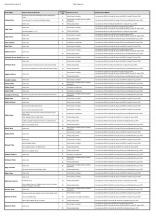
  • Please check the alphabetical listing of Schedule I impacted roads


Schedule II

Yellow line parking restrictions (green on map)

  • Vehicles are prohibited from parking on the single yellow lines: for some roads the measure is in place between 10am and 8pm on the Sunday and Monday; and on other roads between 7am and 11pm on other roads on Sunday and Monday 
  • Please check the alphabetical listing of Schedule II impacted roads.

Schedule III

Safety zones with restricted vehicle and non-resident pedestrian access (blue on map)

  • Vehicles cannot use Schedule III roads between 6am and 11pm on Sunday and Monday of Carnival
  • Pedestrians cannot access these roads between 6am and 11pm on Sunday and Monday, unless they are a resident, and can provide a form of ID as proof of residency.
  • Between the hours of 6am and 8.30am only, on Sunday and Monday of Carnival, residents living in these roads, or a business with a legal interest in a business premise in the these roads can only move their vehicle out of the Safety Zone.

Schedule IV

Option for one-way pedestrian system (yellow on map)

  • In the interests of Public Order and Safety, the Police may feel it necessary to restrict pedestrians from entering or being in this road, between the hours of 7pm and 11pm on Sunday and Monday of Carnival
  • Residents will be allowed to enter this road in such circumstances, on foot and with a form of ID as proof of residency.

Schedule V

Option for pedestrian closure (turqoise on map)

  • In the interests of Public Order and Safety, the Police may feel it necessary to restrict pedestrians from entering or being in these roads at any time.
  • Residents will be allowed to enter these roads in such circumstances, on foot and with a form of ID as proof of residency.

Schedule VI

Parking bay suspensions (not on map)

  • There are a number of bay suspensions with different days and times of operation, so please check the alphabetical listing of impacted Schedule VI roads.

Please contact the Carnival Office for information or enquiries about the road closures:

Last updated: 15 July 2020